 Slaves, Salt, Sex & Mr. Crenshaw
The Real Story of the Old Slave House and America's Last Station on the Reverse Underground R.R.
 Gallatin County, Illinois, Slave & Emancipation Records, 1839-1849
John W. Allen's 1950 transcription of the now-missing second slave registry.
 Handbook of Old Gallatin County & Southeastern Illinois
The must-have book for any southeastern Illinois genealogist or researcher.
| More mysteries uncovered, more left to be solved | ||
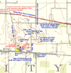 This 1916 closeup map of the Hickory Hill area shows the sites of the Old Slave House and some of Crenshaw's other buildings.
|
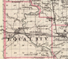
EQUALITY, Ill. (Aug. 1, 2004) — If the Illinois Historic Preservation Agency ever gets any money for the Old Slave House one of the first things they want to do is commission a historic structures survey for the site. Such a survey, usually conducted by an outside architectural group with experience in historic sites, would investigated the architectural history of the house and to some extent its setting on Hickory Hill.
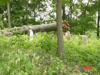
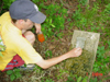
Think of it as a forensic architectural survey, an investigation to the changes that have been made over the years with the goal of discovering what the house originally looked like and how it was built. There have been relatively few changes in the house over the decades and a survey should show that, but it could also solve some additional mysteries as well. The cornerstone in the porch foundation in front gives a date of 1838, but accounts of the house in the 1930s often used a date of 1834 for its construction. The later date fits better with Crenshaw’s business empire, but the earlier year could refer to a start date on a possibly forgotten first phase of the house. While we’ve found no documents, letters, or family folklore that suggests the house was built in two phases, the presence of the conflicting years as well as the northwest corner of the house offers us the possibility of the house being built in stages. The first two floors of the house are designed with four large rooms in each corner with a central hallway or hallway/carriageway combination running down the center of the house. The northwest room of the house has its own cellar with access from the first floor room, as well as its own stairway to the second floor. As such it could be considered self-contained, and thus just might predate the rest of the house. That’s one question that won’t be answered until architects can get in there and look inside some walls. Today there are only three buildings on the grounds, a garage/shed on the north side of the parking lot, a long display building northwest of the main house and a reconstructed slave cabin brought from Tennessee in the northeast corner of the yard. None of the buildings are original to the site and only the slave cabin dates to the 19th Century, though just not in Illinois. So what are we missing? A year or so after we started researching into the site’s history, Ron Nelson and I visited the Old Slave House, and with its then owner George Sisk, attempted to "witch" the backyard with brass witching rods. I don’t know how it works and I’m not willing to a cemetery and try to tell you the gender of each grave’s inhabitants by the bouncing of the rod, but I will tell you they do work much like any metal detector of the high-tech wands utility crews use to locate underground lines. Around the house the rods crossed above points where the earth had been disturbed or compacted over the years. Not only did we find old cisterns, the current septic tank, and a few other minor items out front, we also found paths, lanes and probably building sites. We were looking for outbuildings and other structures. The most obvious of the missing was the cookhouse or two, as the Old Slave House, like many other large structures of that time period did not have interior kitchens. We think, we believe, and former owner George Sisk backs this up, that the cookhouse stood to the northwest of the house where the large display building now stands. George found sandstone foundation pylons when building the current structure. One of those stones still sticks out from the new foundation on the north side. There was also a large barn. George tells us that his grandfather told him it was so big that the whole slave house could fit inside. We do know that in 1887, the largest barn in Saline County immediately to the west and up the road from Equality going to Eldorado belonged to David Westbrook and stood 60 x 130 feet. Having "witched" the site, we think the Crenshaw barn would have been about the same size. Interestingly, Westbrook was shirt-tail kin to John Hart Crenshaw as we say in Southern Illinois. His brother William married Mary Taylor, the sister of Sina Taylor, Crenshaw’s wife. At least two of his brothers, Samuel and Lewis, either worked at the saltworks or for Crenshaw at different points in their life. The barn stood immediately east of the house on another little rise of Hickory Hill on property not purchased by the state. It burned in the late 1920s according to a cousin of George’s who lived in the house in the 1920s, the late Bill Maxwell, whom I had a chance to interview in 1996. A lane ran west out of the barn and along the back side of the house. Like every farm there must have been a number of other outbuildings of various sizes that we think stood north of that land and between the house and the barn. To the northwest of the house we found a path that ran from the original side entrance to the house northwest to the south side of the modern display building and the site of the old cookhouse. On the other side of the building the path continued into the field on the other side of the fence. Before we found the path we found another rectangular building site between the display building and fence. We tracked the path to the edge of the hill where we found 13 building sites in two rows, one of 5, the other of 8 small cabin size impressions. Normally on flat ground you can’t see anything from an old site, but there on the edge of the hill we could actually see indentions in the hill side where buildings might have once stood. Could these be the missing slave cabins mentioned in one of the family letters? Right now our best guess is yes. Although it no longer flows, probably due to underground mining in the area, a natural spring provided water on the other side of the little valley on what has been the Sanks farm since 1853, when Crenshaw’s son-in-law John E. Hall sold 300 acres to George D. Sanks. George Sisk first told us about the spring, which he had heard about growing up. Sanks’ 97-year-old granddaughter Celeste Bennett of Shawneetown also recalls the spring and the night the barn burned. Today only one road leads up to the Old Slave House, the township lane running west from Route 1 — Crenshaw Lane. There used to be two more lanes running north-south near the house. Both ran south from what is now old Route 13 or Walnut Lane today down to Crenshaw Lane, which originally extended much farther west towards Equality along the old Louisville & Nashville Railroad, long gone as well. Strip-mining in the early 1950s cut both of those roads off from the east-west township lane so today they both simply dead-end. The one on the east side of the house is now known as Lawler Cemetery Lane and it now ends at the Hickory Hill/Lawler cemeteries that set side by side. The other lane, Hickory Hill Lane, ran on the west side of the Old Slave House and now ends at the Sanks house, which is the house immediately north of the Old Slave House and the only one visible to visitors standing in the back yard. The Hickory Hill and Lawler cemeteries look like just one, but were originally two. The Crenshaw side being Protestant and the south half consecrated as a Catholic burial ground for Crenshaw’s son-in-law Michael K. Lawler and his family. Originally, both had iron fences around them to keep out the livestock. Today on a corner post or two remains hidden in the undergrowth of the woods and no fence stands to block kids on four-wheelers from cutting across the resting ground. Gallatin County historian and cemetery transcriber Glen Minor called the Hickory Hill cemetery the "oldest one recorded" in Gallatin County. However he based his judgment on the tombstone inscriptions, which normally would be a legitimate way to date a cemetery. The two most massive tombstones in the cemetery are located close to the lane and sit side by side. The one on the north memorializes Crenshaw’s parents William and Elizabeth. The second one does the same for Giles Taylor, Crenshaw’s father-in-law and one of the author’s fifth great-grandfathers. William Crenshaw died in 1815 and his wife in 1829, but they are believed to have been buried on William’s original home place on Eagle Creek southwest of Equality in what is now Saline County. Crenshaw added their monument at Hickory Hill much later. Likewise, his brother-in-law Edmund Dick Taylor erected the second monument for his father Giles Taylor. What’s not known is if the monuments were part of some type of competition on who could top whom in erecting the most massive or tallest monument. Giles died on August 30, 1830, which is also before Crenshaw entered the land at the cemetery. The third tombstone likely added after the fact is a small one for Crenshaw’s infant daughter Nancy who died in 1826. Crenshaw didn’t buy the land where the cemetery sits until January 27, 1831, when he patented the 80 acres on either side of the cemetery lane. He paid $1 an acre for the land. Minor found another child’s grave, this time for Alexander, son of J. & S. Crenshaw dated 1834. Crenshaw’s son Alexander died on September 20, 1834, ten days after his fifth birthday. Although Minor didn’t find it there is probably a stone around there for John Alexander Crenshaw who died June 1, 1835, nine months after being born the day after brother Alexander’s fifth birthday. If Crenshaw put up a marker for his daughter Nancy, then he probably added another one for his fourth child Francine or "Sina" who was born on July 16, 1823 and died four months later on September 20. Likewise a thorough search and restoration of the cemetery might uncover the tombstone for Crenshaw’s 10th child Hannah who also died young on March 15, 1839 less than two years old, her birth having taken place on October 22, 1837. The first burial in the Lawler Cemetery didn’t take place until a half century later according to Minor. Lawler himself had the oldest tombstone. He died in 1882. The cemetery lane probably represents the oldest road around the site of the Old Slave House and would date to the early 1830s running south from modern Old Route 13, then the rough alignment for the main rock road between Shawneetown and Equality. Later that decade while the house was being built workers built the railroad grade below the front of the house between 1838 and 1840. When the railroad failed to get off the ground, the county temporarily took over the right-of-way and made it the new major east-west route. In 1842, county commissioners made the cemetery lane part of a new county road that passed by "Crenshaw’s barn". The road on the west side of the house came later. On December 5, 1867, George D. Sanks petitioned the county asking that "viewers be appointed to view and locate a new road beginning at the Equality and Shawneetown road between Mr. Folsom and Fowlers farms North to the Section line at the South West Corner of the school lands and follow said Section line to the Equality and New Haven road." Crenshaw had sold the Old Slave House to James S. Folsom in 1864. On the same day he sold land farther to the west to Lewis W. Fowler. Hickory Hill Lane, if extended south to the railroad tracks and modern-day Crenshaw Lane would split the two farms. An 1876 county map also shows a short lane running between the two lanes along the property line dividing then the Sanks and Folsom farms and now the Sanks and Sisk farms. Though long abandoned by the township, remnants of that lane can still be seen. When we were "witching" we found a lane running immediately north out of the back of the Old Slave House’s carriageway down to that lane. That probably was the main way to get to the house. There’s still more exploration that needs to be accomplished and more land to be acquired. Both should happen if the state ever decides to move forward on the Old Slave House. Let the governor know that it’s time for both to move forward.
| |
|
|