 Slaves, Salt, Sex & Mr. Crenshaw
The Real Story of the Old Slave House and America's Last Station on the Reverse Underground R.R.
 Gallatin County, Illinois, Slave & Emancipation Records, 1839-1849
John W. Allen's 1950 transcription of the now-missing second slave registry.
 Handbook of Old Gallatin County & Southeastern Illinois
The must-have book for any southeastern Illinois genealogist or researcher.
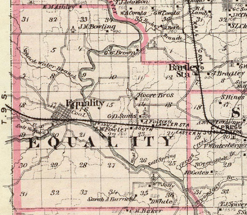 Map: Warner & Beers. 1876. "Map of Gallatin and Hardin counties, Harrisburg and Elizabethtown." Atlas of the State of Illinois. Chicago: Union Atlas Co., Warner & Beers, Proprietors. 134. 1876 EQUALITY TOWNSHIP — This close-up of the 1876 state atlas identifies the Old Slave House in the center of the map under the name of A. Folsom, for Albert Folsom. The St. Louis & South Eastern Railroad followed the same grade built in 1838 to 1840 for the Shawneetown & Alton Railroad. George D. Sanks purchased his farm immediately north of the Old Slave House in 1853 from Crenshaw’s son-in-law John E. Hall. Family tradition states that the Sanks family lived at Crenshaw’s Hickory Hill until they finished their own house. That house is still standing and remains owned by the family. L. W. Fowler purchased his acreage off of Crenshaw in 1864 on the same day as Folsom bought the house and the 300 acres around it. The Gallatin County Commissioners authorized the road running between the two farms as shown on the map in 1868. Most of that road still remains except the portion south of the Sanks house. The short lane dividing the Sanks and Folsom farms probably goes back to the construction of the Old Slave House in the 1830s as a private lane for Crenshaw. The portion of it that turned north until it hit the main east-west road in the middle of Section 14, became a county road in September 1842 and at that point ran south to the railroad grade as either the grade or a road running along side it became the main east-west route. The school house shown next to the Sanks house is the Hickory Hill school which stood across from the Hickory Hill/Lawler Cemetery. The Salt Spring in Section 26 south of the Folsom house was the original site of the saltworks for Native Americans. During the operation of the saltworks by the Americans it became known as the Lower Lick. The upper lick, or Half Moon Lick can be seen by the "Salt Works" designation southwest of Equality. The railroad junction of Cypress Junction marked the site of Crenshaw’s Cypressville mill that burned in 1842. The "Moore Bros." site northwest of the Old Slave House may have been the site of Crenshaw’s offices for his saltworks. John Carter who used to lived on that site told George Sisk that was the case. That land was part of the land Crenshaw lost to his son-in-law John E. Hall, who sold 200 acres there to George Moore on Feb. 17, 1853. He paid $2,400 for the land which is too much just for acreage. There must have been some type of building there. He purchased the NW 1/4 as well as the W 1/4 of the NE 1/4 of 14-9s-8e. Also, the J. M. Bowling in 34-8s-8e had a son William H. who married Mary Edna Foster, one of Crenshaw’s great-granddaughters. |
|
|