Coming this Fall 2004
 Slaves, Salt, Sex & Mr. Crenshaw
The Real Story of the Old Slave House and America's Last Station on the Reverse Underground R.R.
Now Available
 Gallatin County, Illinois, Slave & Emancipation Records, 1839-1849
John W. Allen's 1950 transcription of the now-missing second slave registry.
 Handbook of Old Gallatin County & Southeastern Illinois
The must-have book for any southeastern Illinois genealogist or researcher.
|
|
|
So...
How much land did Crenshaw actually own? |
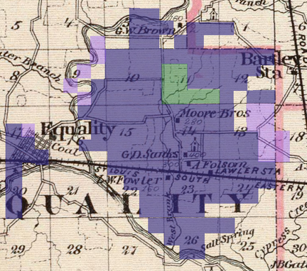 Base Map: Warner & Beers. 1876. "Map of Gallatin and Hardin counties, Harrisburg and Elizabethtown." Atlas of the State of Illinois. Chicago: Union Atlas Co., Warner & Beers, Proprietors. 134.
CRENSHAW’S LAND EMPIRE — Crenshaw centered his Illinois holdings around his manor home atop Hickory Hill, which is shown near the center of this map as the small rectangle next to "A. Folsom" the owner of the house in 1876. The lighter shaded purple lands around the edge of the main holdings belonged to Crenshaw’s brothers, nephews, in-laws and their relatives. The green shaded area in Section 11 in the northern half of the main holdings were swamp lands or wetlands not entered until after the Civil War by persons other than Crenshaw. He was constantly buying, selling, mortgaging and losing his lands in judgments so the boundaries of his holdings changed dramatically over the years. The shadings above show the maximum extent in his key holdings in Equality Twp. The land around Equality itself actually didn’t include the original plat of the city, but the land around it. Each numbered section in the map generally contains 640 acres or one square mile. Crenshaw owned around 5,720 acres immediately around Hickory Hill in the area generally bounded on the north and northwest by the North Fork of the Saline River and on the southwest by the Saline River itself. Relatives owned another 520 acres and swamp lands totaled around 320 acres. All told the main sold mass totaled around 6,560 acres. This does not includes the lands shown west and south of the Saline River.
Base Map: Warner & Beers. 1876. "Map of Gallatin and Hardin counties, Harrisburg and Elizabethtown." Atlas of the State of Illinois. Chicago: Union Atlas Co., Warner & Beers, Proprietors. 134.
CRENSHAW’S LAND EMPIRE — Crenshaw centered his Illinois holdings around his manor home atop Hickory Hill, which is shown near the center of this map as the small rectangle next to "A. Folsom" the owner of the house in 1876. The lighter shaded purple lands around the edge of the main holdings belonged to Crenshaw’s brothers, nephews, in-laws and their relatives. The green shaded area in Section 11 in the northern half of the main holdings were swamp lands or wetlands not entered until after the Civil War by persons other than Crenshaw. He was constantly buying, selling, mortgaging and losing his lands in judgments so the boundaries of his holdings changed dramatically over the years. The shadings above show the maximum extent in his key holdings in Equality Twp. The land around Equality itself actually didn’t include the original plat of the city, but the land around it. Each numbered section in the map generally contains 640 acres or one square mile. Crenshaw owned around 5,720 acres immediately around Hickory Hill in the area generally bounded on the north and northwest by the North Fork of the Saline River and on the southwest by the Saline River itself. Relatives owned another 520 acres and swamp lands totaled around 320 acres. All told the main sold mass totaled around 6,560 acres. This does not includes the lands shown west and south of the Saline River.
|
|
EQUALITY, Ill. — It’s a good question and one that we can’t definitely answer.
So far we’ve found around 15,000 acres in two states, 11,000 acres in southeastern Illinois and 4,000 acres in Tennessee. We say "around" because some of the deeds contain mistakes in the legal descriptions. Sometimes we’ve found lands that Crenshaw mortgage, but have never found the deed where he initially purchased the land.
|
|
An obituary of his son William T. Crenshaw published in 1903 noted that the father had owned 22,000 acres of land. Two years later another branch of the family used the figure of 30,000 acres in a biographical sketch of Crenshaw.
Most of the land in Illinois is located in Gallatin County with some in southern White, eastern Saline and northeastern Hardin counties.
His biggest chunk of land pretty much centered around his manor house atop Hickory Hill, the home known today as the Old Slave House.
Crenshaw’s main plantation at Hickory Hill included about 5,720 acres at its largest point in time.
Some of earliest parcels purchased came after his first kidnapping indictment in the 1820s, the kidnapping of Lucinda and her two children in 1827 and the sale of Frank Granger and 15 others in Tipton Co., Tennessee, in 1828, which is also when he purchased his Tennessee lands.
— Jon Musgrave
|
|
Back to the front of the Summer 2004 newsletter
Last updated August 1, 2004 — Back to the Illinois History Page
| About the site |
Basic categories |
Search this site |
©2004 Jon Musgrave
|
|